 |
| via The New York Public Library Digital Collections |
Possibly James McCune Smith knew both of the Messrs. Gulick, although it is not made clear to whom their quoted "letters" from Micronesia were originally sent: to Dr. McCune Smith personally, or a mutual friend, to the Geographical Society itself or a scientific journal, to a missionary journal or other religious periodical? The elder brother, Luther Halsey, and McCune Smith were linked (after LHG's graduation in 1850 with a medical degree from New York University) as fellow physicians and avowedly Christian reformers. In 1851, Luther Halsey Gulick had been ordained in the Congregational Church at the Broadway Tabernacle, historically a venue for social and political activism. In her History of the Broadway Tabernacle, Susan Hayes Ward quotes William B. Holmes, who recollected that
"... the Tabernacle was the forum where reformers of every class and advanced thinkers of every name and sex held forth, and, usually, to large audiences."The sermon there by pastor Joseph P. Thompson, generally regarded now as an anti-slavery moderate, alluded to Herman Melville as
--Broadway Tabernacle, 79
the dreamy author of "Typee" and "Omoo"... --Moral Unity of the Human Race, 16
Younger brother John Thomas Gulick would visit Melville at Arrowhead in April 1859.
Here then, a Melvilliana exclusive! You won't find this in the Works of James McCune Smith! (But let's hope for a second, expanded edition.) Some obvious errors and typos I silently emend, for example "Pritchard" has been corrected to "Prichard" throughout. Otherwise, the text of Dr. McCune Smith's presentation is transcribed below from the
Here then, a Melvilliana exclusive! You won't find this in the Works of James McCune Smith! (But let's hope for a second, expanded edition.) Some obvious errors and typos I silently emend, for example "Pritchard" has been corrected to "Prichard" throughout. Otherwise, the text of Dr. McCune Smith's presentation is transcribed below from the
New York Daily Tribune, Wednesday, June 15, 1853.Images of the original article are accessible online at
THE MICRONESIAN ISLANDS.Meeting of the American Geographical and Statistical Society—Paper on the Micronesian Islands.
A meeting of the Geographical Society was held last night at the university. After the usual routine of business, Dr. J. MCCUNE SMITH, of this City, read the following interesting Geographical and Ethnological paper:
GENTLEMEN: The papers upon which I have the honor to present the following report relate to several islands in Micronesia. They were written by Rev. Dr. L. H. and Rev. John T. Gulick, natives of the Pacific and sons of an American missionary. They were educated as missionaries in the United States, and have signalized their return to the scene of their birth and future labors, not only by a devoted zeal in Christianizing the heathen, but also by these interesting researches, the object of which is well expressed by Dr. Gulick in the following terms:
“As we proceeded (in our missionary schemes) from island to island, the languages, manners and customs of the natives have been objects of interesting study, as monuments on which are graven the names of distant islands, once the home of their forefathers, and as relics and tokens received from their ancestors by which they may prove their direct descent from Adam, and demand the rights of freeborn citizens of the family of Noah, and by virtue of which they may claim a share in the inheritance of light and knowledge possessed by their kindred in other lands.”
It may be well to preface the analysis of these papers with a few remarks on the geography, &c., of Micronesia, and the Micronesian Archipelago, which embraces, according to Dr. Prichard, “A space in the ocean, interspersed with islands of small extent. It comprehends the Western part of the North Pacific—in other words, a great tract of that ocean lying to the northward of the equator, and between that line and the northern tropic, and in longitude included between the meridian of the Fegee Islands and the extreme border toward the ocean of the Philippine Archipelago and the insular Empire of Japan. Within these limits Micronesia comprehends the group of the Ladrones or Marian Isles to the northward, and nearer to the equator, all those clusters of islands lying under the same parallel of latitude, which, in recent times, have been comprised under the name of the Caroline Archipelago. All the Micronesian Isles, as the name implies, are of small extent.” [James Cowles Prichard, Researches into the Physical History of Mankind, vol. 5 (London, 1847), 155]
The origin of these islands is, no doubt, from the upheaval of the submarine crust of the earth; which power having, in most instances, thrown up the craters of extinct volcanoes to within the distance of the surface of the ocean inhabited by the coral insect, this tireless laborer constructs thereon what becomes the rim of a lagoon—hence the coral islands. Occasionally the same upheaval force thrusts the peak of a submarine mountain above the surface of the ocean, constituting a second class of islands; in these latter cases, we find not only the soil and the vegetation, but even the human species presenting striking differences from the products or inhabitants of the coral islands.
The Messers. Gulick state that the people of Taritari and Makin, coral islands in the Kingsmill Group, are large in stature and gross and corpulent in person; while the inhabitants of Nalan and Bonabe, mountainous islands, are small in stature, and of well knit, wiry frames. Similar differences are found between the Highlanders and Lowlanders of Scotland, and elsewhere.
The islands of Micronesia lie in clusters, having a definite direction, indicating the range of submarine mountains of which they are the summits. Although this and the adjacent portions of the Pacific have been well and continuously traveled during the last two and a half centuries, by Jesuits in search of converts, merchants seeking trade, by adventurers in search of gold, by ocean freebooters and by exploring expeditions specially sent out for geographical discovery, yet it is very remarkable that many of these islands have been discovered within the last half century, while others, accurately laid down before that period, have disappeared; showing that the upheaval and subsidence of the earth’s submarine crust must be actively at work elevating and submerging the islands of the Pacific.
The race, language and history of the Micronesians, while they have little to distinguish them from the rest of Polynesia, yet contain, in common with the latter, proximate solutions to some interesting problems in Ethnography and Ethnology. All the aboriginal inhabitants of Polynesia are classed as Malays. Polynesians and the study and comparison of their languages, thus far, indicate a common origin from the Sanskrit; they appear to be derived, however, from the earlier or rude form of that language, or that form which preceded the Classic era of that tongue; and it is from the Classic era that the language of the Telaigi of the Greeks, and subsequently the Germanic races, are derived.
Hence it follows that the migration in the southwest corner of Asia, from which the great Malayan race and its Polynesian offshoot sprang, really dates anteriorly to the great European migration. An ethnological fact, to which we have analogies on our own continent. Many words, now used in New England, after affording much mirth to modern English critics, on a careful comparison have turned out to be the ipsissima verba with the identical meanings attached to them by the English people of the time of the Puritans. And Monsieur Ampere has, within the last year, made a similar discovery in relation to the patois of Canada.
But the most remarkable fact in the history of the great Malayo-Polynesian race, is this: they have spread over 100 deg. of latitude by 120 deg. of longitude, really 190 deg. longitude, as they are found in Madagascar, or the enormous area of 58,000,000 of square miles! And their empire is the ocean, over which they have spread by no other means of conveyance than their small and frail canoes. No migration of one variety of the human race since the world began has been half so extensive or extraordinary; and if we compare these island people, their fine physical condition, their inventions of the loom and the compass, their rude agriculture, their highly poetical myths and their dim recognition of a Supreme Being,—if we compare these with the total ignorance and bestial imbecility of some varieties of mankind—the Dodos in Africa, the Diggers in Utah and the Alfouroos in New Holland, pent up in the centers of vast continents—we at once perceive the immense value of water, or coast vicinity, as a stimulus to human ingenuity; and we are forced to admit, with the learned Ritier, the great dependence of civilization upon the relation between the extent of coast and continent, in any portion of the earth’s surface. Compare the persistence in retaining language by these islanders from before the Christian era, with the fluctuating languages of the Bushmen, who have a new language for every new expedition, and whose hissing words are as indistinct as those of a goose or a serpent.
The reasons which identify the Micronesians with the great Malayo-Polynesian family, are the following:
1st. A comparison of vocabularies exhibit analogies which, according to the principles laid down by M. Abel. Ramesat, show an identity in the original languages of the various islanders. And the vocabularies of the language of the people of Taritari, Kusaia, Bonabe and Hawaii, furnished, in the papers before us by Rev. J. T. Gulick, throw great and valuable light on this point, especially in the important matter of the numerals.
2d. The thieving propensity is common to Polynesia from the Ladrones, or Thief islands, so called by the old Jesuits, the earliest Missionaries to the Bowditch islands, the latest discovered among them. Indeed, the reception of Capt. Wilkes and suite, with celestial honors, and the simultaneous thefts perpetrated upon them by Bowditch islanders lead to the suspicion that stealing may be a part of their worship as well as of the worship of some of their human brothers of higher pretensions to civilization.
3rd. Their common bent to the use of numbers. Mr. Gulick’s vocabulary contains terms of the Micronesian islanders visited by him, for numbers as high as millions. And Captain Wilkes states that in the native Schools at Honolulu, the severest punishment is, to restrain the pupils from the study of Arithmetic. A striking contrast to the Continental Esquimaux, who count ten only.
4th. Their reverence for, often amounting to worship of, the dead. M. de la Gironiere, (Sunday Times, May 8, ’53,) mentions this peculiarity even among the Ajetas, a remote tribe in one of the Philippines. He supposes them to be negroes; but they are simply a variety of Polynesians exhibiting the peculiar complexion and hair, which their geographical position would stamp upon any portion of the human race.
5. Their similarity in complexion, hair and features. Wide difference shave been asserted to exist, in these particulars, but on almost any given Island, may be found differences as great, as in any two of the most remote Islands. And these differences, the result of caste or relative exposure, are no where greater than may be found between the lowest ranks and the nobility of Great Britain.
With these preliminary remarks, we proceed to the analysis of the papers.The first Island visited, and described by the Dr. L. H. Gulick, is Taritari, of the Kingsmill group. It lies in lat. 3 deg. 7 min. N., and lon. 172 deg. E. This Island had been visited and surveyed by Capt. Wilkes, nearly ten years before; and the account of it contained in the fifth volume of his narrative, coincides with that contained in the papers before us, in all, except two particulars. Capt. Wilkes considers the Island of no present or prospective commercial importance. Mr. Gulick shows that the Islanders export 1,200 barrels cocoa nut oil annually to Sydney; and adds, that by a little economy in the mode of preparing it, this quantity may be doubled; and further, that a large quantity of cocoa nut molasses, obtained after the manner of securing maple sap, may be manufactured. There is also, scattered over the Island, a quantity of lime stones, which are valuable inasmuch as they are obliged to obtain lime for the Sandwich Islands, from around the Horn.
Capt. Wilkes states that there are but few children on the island. Mr. Gulick asserts that there are many. Capt. Wilkes, in 1842, thought this island to be decreasing in size; Mr. Gulick, in 1852, is of opinion that it is increasing; two statements not incompatible with the upheaval theory of Dr. Sir Charles Lyell.
The population of Taritari, is estimated at 2,000 by Mr. Gulick, and on the fifteen islands composing the Kingsmill group, at no less than 47,000 souls.
Kusaia, or Strong’s Island, is the next visited by our narrators. It is the most easterly of the Caroline Group, and lies in lat. 5 17 deg. North, and lon. 163 deg. East. Capt. Wilkes did not visit this island. It was discovered in 1804, by Capt. Crozier, and named by him after Gov. Strong, of Massachusetts. It has also been visited by Dupeny and the Russian navigator, Lutke.
The name Kusaia is applied to two adjoining islands, the larger, called Nalan or Strong’s Island, and the smaller Silla or Sela; the latter is the residence of the Kings, and is remarkable for some stone inclosures.
Nalan, or Strong’s Island, is hilly, its highest elevation being 2,200 feet: it might be said to consist of two peninsulas, each having its central mountain, with spurs traveling to the shore. The northern sustains Mount Banache, the southern Mount Crozier. The island is probably thirty miles in circumference, and has an eastern, southern and western harbor, the eastern being by far the best.
The appearance of the island is very romantic. Its thick robe of green, reaching to the water’s edge, betrays unusual luxuriance. Frequent showers upon its rich mold conspire to bring in a very rapid vegetable growth, some of the reports of which seem incredible. Corn, it is said, comes to full maturity in six weeks. And sugar cane is said to grow, occasionally six fathoms long. The growth of timber certainly exceeds anything in the Sandwich Islands.
The inhabitants of Kusaia are generally small in stature and of a light copper-colored complexion. (The King and some of the nobles are men of large stature.) Hair long, fine and black, and dawn back and tied upon itself in a large knot; eyes sunken, with the obliquity of inner angles peculiar to the Chinese. This latter peculiarity led D’Arville to claim for them a Chinese origin, which, however, their language forbids.
The manners and address of the Kusaians were so mild and agreeable as to lead the Messrs. Gulick to deny the appropriateness of the term “savage” when applied to them. The number of inhabitants is not mentioned.
Admiral Sulke , [Lutké] quoted by Prichard, remarks of these people, " Ils ne viennent point à la rencontre [d'un inconnu] avec des branches de palmier ou tout autre signe de paix, parce qu'ils ne connaissent pas d'autre état que l'état de paix.”
Notwithstanding this high compliment, these islanders can kill on occasion, having cut off two ship’s crews, the last on the civilized maxim that dead men tell no tales. (See Gulick Letter, Sept. 1852, p. 7.)
These people manifest the usual Polynesian aptitude in the construction of causes, and have attached to them outriggers surmounting, in cases of the nobility, with a species of coat of arms made of rare shells. They have a native cloth woven (in a loom) from the banana fibre, in strips quarter of a yard wide and worn about the loins by both sexes. In place of warmth of clothing they make fires within their houses.
Their form of Government is an absolute monarchy, hereditary as a general rule, although the direct line is sometimes interfered with by election or changed by revolution. There are several orders of nobility in which caste is rigidly maintained. The King and the nobles are the artizans, each following the calling of his father. The present King is a fisherman. Among the artisans are canoe-builders, house-builders, preparers of wava, their food, and kaava, their drink. These callings are considered honorable, and the common people or serfs are not permitted to follow them.
They have the taboo, which is indicated by leaves placed in certain directions. They have but one wife, although divorcement exists.
Their disposal of the dead is peculiar. After death, the body is thoroughly saturated with cocoa-nut oil; it is then carefully and tastefully wrapped with different colored cloths from head to foot; in two or three days it is buried in a grave, and left there three months; then it is dug up, the bones tied together and sunk in a particular spot in the harbor. In the case of the King’s daughter, deceased three months before the arrival of the Messrs. Gulick, the body was still kept above ground, in a large house, watched by the principal Chiefs, who lived meanwhile at the royal expense. This body was probably intended for sepulture in one of the vaults on the Island of Litta.
Dr. Gulick regards the account of the stone structures, in the last-named island, as greatly exaggerated by D’Urville. He says: “The reported piles of masonry were large rough stones laid up to a considerable height. We found a number of these walls, of various length, and in various conditions of perfectness. Large Banyan-like trees had, in many instances, sent their roots into the center of these structures; and in these cases the stones have been removed, probably for building purposes.
A wall varying in height, in different parts, surrounds a considerable part of the hill which occupies the centre of the Island. Another wall is near the present residence of the King’s oldest son. Its length is about 219 feet, its breadth 108 feet, its hight about 20 feet, and thickness 12 feet. It is in good condition. There were but two original entrances, both from the north side, now mere gaps in the wall. Upon entering, a smaller wall, perhaps five feet in hight, divided the area into two compartments, with one of the gaps entering each. This wall consisted of stones, large and small: some irregular masses, others five-sided basaltic prisms, which are found in various parts of the island. No trace of hewing or cutting by human agency was anywhere visible.
The King informed me that these walls were built by the former inhabitants as a defence against the people of the larger island. And when asked how the large stones had been raised so high, he replied that they had been rolled from level to level on inclined planes of wood and stone.”
Bonabe, Ponypet, or Ascension Island is the name of the last one visited by the Messrs. Gulick. It was discovered by Lutke in 1828. The circumference of its surrounding reefs is 60 miles; its southern harbor is in lat. 6 31, N., and long. 158 24 E. It is mountainous, and several streams running from the mountain sides have, by their force, formed a small archipelago at their mouths; each island being docked up with stone walls. It has no less than six harbors: Mantalanim, the site of the remarkable walls, Bonatick, Paman, Roach, Rono Kittie, and Saket’s Bay. Of these, Paman, with a depth of 25 fathoms and Rono Kittie are decidedly the safest for sailing vessels, being never wind-locked. In the latter harbor are two pilots and quite a number of vessels stopped there during the twelve months before Mr. Gulick’s visit. Game, fowls, pigs, and wild pigeons are the fresh provision now furnished, but the resources of the island are almost unlimited, and will yet furnish many gardens and plantations for the supply of all foreign demands. There is also an abundance of fresh water, a luxury not to be had, for obvious reasons, in the coral islands.
The most remarkable objects on this island are two ruins of large enclosures, analogous to those found at Lilia in Kusaia, and which have given rise to various conjectures as to thie builders and their purposes. The following is Dr. Gulick’s account of them:
“We approached them in a canoe from the West, paddling from the harbor (of Mantalanim) over a long flat or shoal, till we found ourselves passing between several little islands covered with cocoa nuts and other trees. There was nothing striking in the appearance of these islands except the stone work which forms the border of each, preserving it from the wear of the waves, and making it a regular parallelogram in form.
These works are built in a rough but substantial manner from stones of all sizes, many of which are basaltic prisms. The top of the buttress is in most places above the level of the water, though, when the general level of the island is much above this, it is carried up to a proportionate hight. These islands and the shallow channels that separate them are probably the fine wharves and streets described by some who have visited the spot; but I must say that I find it difficult to fall in with this idea.
It is much more probable that these are natural islands formed by the fresh water streams that empty through these many channels. Those who once occupied them obviously spent much time and labor in building the buttresses, most probably for the purpose of protecting them from the force of floods in the stream above and from the more constant wear of the tides and waves, though the regular and improved appearance that such works would give to the place, and the convenience they would afford for landing from boats or canoes, may have been additional inducements.
Mr. Corgat, who was our most reliable informant, told us that there were 15 or 20 islands in that vicinity, separated from each other by a labyrinth of ‘creeks,’ which is the term that foreigners in Bonabe apply to their fresh water streams. We find islands at Rono Kittie formed in the same manner by the streams which divide into several channels, but not so widely as at Mantalanim, for there is not so broad a strip of lowland.
We were told that in the centre of one of these islands near the ruins, is a pond in which the natives keep a large sacred eel. Our informant said that the keeper who takes food to the eel, always approaches the pond walking backward, that he may not be guilty of even looking at the sacred fish. When he comes to the brink of the pond, he reaches the food out behind him, lets it fall into the water and runs speedily away, reversing the order of retreating from majesty on the part of certain civilized nations.
As the tide was low, we were obliged to land on an island lying close to the one on which the principal ruins stand. A few rods through the trees and bushes brought us into full view of the structure from which we were separated by a shallow channel thirty or forty feet in width. It presents a front of 160 feet and is 250 feet in length from east to west, occupying a little island about an acre in extent. The foundation platform which consists of the original island with the stone works that surround it, rises about eight feet above the water.
On west side, the walls, which are about 20 feet high, are placed back from the edge of the foundation works, leaving a platform 18 feet wide: but on each of the other sides the face of the wall corresponds with that of the buttress, presenting a perpendicular front 22 feet in hight above the water. Except on the western front, the walls are not only overtopped by large trees, but are even buried in the green foliage of ferns and bushes and long hanging vines.
They appear quite perfect except in one place on the north side, when, for the space of a rod or two, the wall has partially given way on the inner side only.
The walls are almost entirely built of Basaltic prisms of five, six, and seven sides, varying from 18 feet in length, and two in diameter, to the same proportion in inches. They are laid alternately, lengthwise and crosswise the direction of the walls.
There is an entrance 15 feet wide on the western front, and the smaller entrances or openings in the wall on the northern and southern sides.Within the outer bulwarks is another enclosure 75 feet front and 95 feet deep; it has a formidable platform of its own, in which its walls and the main central vault are built. It is eight feet above the main foundation.Between the walls, therefore, is a walk 20 feet wide on the eastern and 12 on the other sides.The inner walls are 12 feet higher than the platform, and 2 feet lower than the outer walls.The thickness of the outer walls vary from 18 to 6 feet. The inner wall is 10 feet thick at the base and 5 feet thick at the summits, with a projecting cornice 2 feet wide.The entrance to the inner wall is of the same width and directly opposite that of the outer wall.In the center of this inner inclosure is a pile of stonework about 12 paces square at the bottom, and 8 or 9 feet in hight. Two surrounding platforms, each a yard in width, divide the ascent to the top into three steps. The top is about 24 feet square.Within this structure is a vault, and in the west side, directly in front of the gateway, there seems to have once been a doorway leading into it, but which is now strongly blocked up. A narrow entrance has, however, been opened on the top, through which we descended and found ourselves in a dark cell 8 feet deep, and 11 by 10 in length and breadth.The only light that reached us entered through the cracks between the long prisms laid across overhead. We remained in it nearly half an hour, turning over pieces of coral and old sea-shells, hoping to find some bone or other relic. The foreigners told us that in 1838, Captain Charles Coffin, of the ship Ohio, Nantucket, and E. B. Sherman, of the Marcus, Fairhaven, visited this vault together, and took from it human bones of gigantic size. We were not so fortunate as to meet with anything of the kind; but we had the pleasure of finding several little snail shells.We visited two other vaults outside the inner walls, in the platform, and not marked by any superstructure. We were told that M. Dudoit, now of the Sandwich Islands, took two silver crucifixes from one of them. There were ten other vaults mostly filled up.Mr. Corgat told us that, formerly, the bones of the kings and high chiefs of the Matalanim tribe were deposited in these vaults, and none but priests dared enter within the enclosure: but of late, since the taboo has been broken over, they are not used for this purpose. The natives, even now, dare not enter the vaults. When we urged one to go in, he replied, ‘No, me die.’At Rono Kitti, half a mile from the shore, is a similar enclosure, more roughly built.”Mr. Gulick, after canvassing the various conjectures as to the uses of these enclosures arrives at the highly probable conclusion that, like the pyramids of Egypt, they were built to perpetuate the memory and mark the sepulture of ancient Kings. For various reasons he is [of the] opinion that they were not constructed by the ancestors of the present inhabitants of Bonabe, or Ascension Isle: these people have a tradition that their forefathers who came from the East, found three men on the island, who were all that remained of the people who had built the stone structures; these individuals were an old man and his two sons, and they were giants. They were then engaged in cutting stone from the bluff called Sugar Loaf. The young men, however, left that work and commenced to dig a channel the island, but this displeased the old man, and as they would not desist he precipitated part of the mountain upon them and crushed them.
Mr. Gulick is of opinion that the present inhabitants of this island are identical in race with the Kingsmill Islanders. Their number is about 5,000 and decreasing. They are divided into five tribes: 1st The Matalanim, the most powerful. 2d. The Kitti. 3d. The Jetroits. 4th. The Nut tribe. 5th. New Tribe. They are also divided into several castes: and this singular law governs all; that marriage must always be effected without the caste; a person may not marry within but always without the caste: the highest caste may marry the lowest, but the children are always of the caste of the mother. Partus sequitur ventrem.
The form of government, as described by Mr. Gulick, is very complicated, and so intervened with castes that a clear explanation cannot be made out from his notes. It would seem that our social reformers would find series and interseries, attractions and repulsions enough to gratify their utmost cravings. Such terms as Jebeydies, Tupenimantonbal, Lipitaus, Tupinwies and Tupenanunbutabuts, are quite as formidable, and perhaps as conducive to passional development as any thing laid down by Fourier—or it might be supposed that they had been quietly emulating the Germans in the invention of unpronounceable names. Of their physical appearance Mr. Gulick remarks:
“They have not the Chinese cast of countenance; they are lighter in complexion than any Ihave yet seen. There is a length &c., and delicacy of nose, which I must speak of as very agreeable, although the expression be a singular one. Among many chiefs the hair is long, and there is generally a wreath or some other arrangement by which it is loosely and elegantly detained; in some individuals the whole hair is curly, which is accompanied with light complexion. The young chiefs certainly excel in delicacy of feature and beauty of complexion. Many of the women are in very positive degrees, beautiful.”
This description contrasts strangely with Admiral Lutke’s. “In character,” Mr. Gulick continues: “they are a very shrewd active people. Expert in making bargains; and having considerable spirit and power of execution. Although from fifty to eighty foreign whites have for many years resided on this island, the natives still maintain perfect control over all their own affairs and the foreigners are kept in some degree or other of dependence. They are fully possessed with the demon of petty thieving; and this they carry on among themselves so that when a man would leave his house he carries with him all his valuables. The population is estimated at from 5 to 10,000, and is decreasing. It is divided into five tribes. The form of government is a limited and somewhat complicated monarchy.”
I have now done with my brief and imperfect analysis of these highly interesting researches. Much has been excluded which would have been nearly as interesting as what has been read to you. The ethnological portion, which is exceedingly elaborate, has been of necessity passed over, and I trust that the learned body to which it properly belongs may give it that attention and credit which it so well deserves.
These researches relate to islands and people, who waft across nearly half the globe, their mute, their dying appeal to the children of light and learning, for life, for Christian Liberty, and the pursuit of that rational happiness with which nature has done so much to endow them.
And they ask for no more than that, which if it be granted them, they will be able to repay in kind. For there is little doubt of the great commercial importance of these islands to a nation, which like ours already claims the Pacific as her own highway. In a letter received from Dr. Gulick, dated Bonabe, Dec. 21, 1852, two months later than the date of the last of these papers before us, he states that not less than nine vessels have visited the island during that time, two of them making it the point of departure for trading expeditions.
By glancing at the map it will be found to lie about half way, in a direct line, between Sydney and Canton. Then glancing from San Francisco to the Southern Chinese coast, it will be found that along with the Sandwich Islands, this same island of Bonabe or Ascension, divides the Pacific into three nearly equal parts, and at convenient, nay, necessary distances for stopping places for steamers on their route, which in a few years must vie in importance with the pathway across the Atlantic.It is exceedingly important, as well as fortunate, therefore, that there are now established upon this island intelligent missionaries, having the broad and liberal views of Dr. L. H. and Rev. J. T. Gulick, who claim a native interest in the preservation and welfare, and eloquently plead for a share of the highest civilization for their Polynesian brethren, as their right, as part of the one human family.
And it may not be out of place for this Society to endeavor, by words of encouragement, to strengthen the hands of these devoted Christian missionaries, in their endeavors to prolong the existence, elevate the morals, and develope the industrial capacities of the interesting people among whom their lot is cast. The establishment of a hospital with an efficient medical force, would be an essential aid in carrying out the views of Messrs. Gulick, and would also be a desirable addition to the many attractions which render Bonabe a convenient stopping place for vessels.
I would respectfully offer the following resolutions for adoption by the Society:Resolved, That this Society has received, and examined with deep interest, the valuable communications of the Messrs. Gulick, concerning Taritari, Kune, Kusaia and Bonabe, important islands in Micronesia.
Resolved, That this Society do earnestly request the Messrs. Gulick to continue their valuable researches into the Ethnology and Ethnography of the Micronesians; and that they be requested to confide the result of their labors to this Society, which will be happy to become the medium of making them known to the scientific world.At the conclusion of the reading of the above paper, a vote of thanks was returned, on the part of the Society, to Dr. McCune Smith.The Chairman stated that he hoped the doings of this Society would confer a great advantage on the country. Indeed he had no doubt but they would do so, unless the body should, by some means or other, be declared unconstitutional.During the reading of the paper, Dr. Smith frequently referred to maps of the places of which he spoke. These maps were drawn and painted by Messrs. George Schroeter and Patrick Reason, to which gentlemen the Society also passed a vote of thanks.A resolution was also passed that the maps be retained and paid for by the Society. The meeting then adjourned.
 |
| Patrick Henry Reason (1816-1898) |
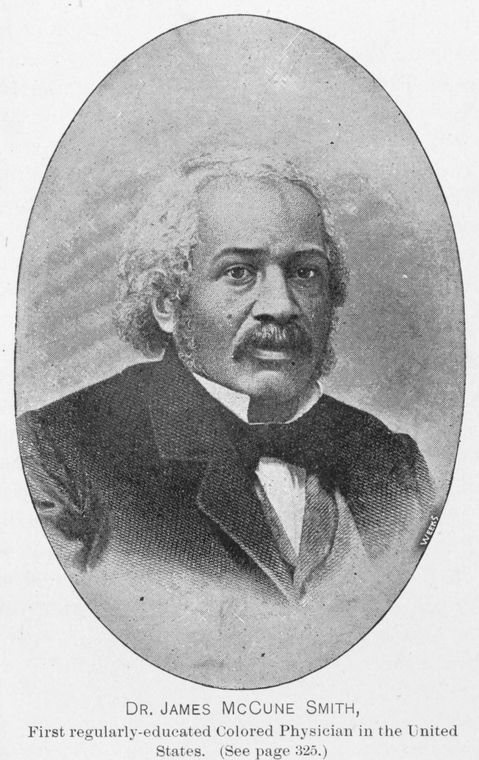
"JAMES MCCUNE SMITH PHYSICIAN AND ABOLITIONIST 1813-1865"Here is the portrait of James Mccune Smith as elegantly engraved by Patrick Henry Reason, via the New-York Historical Society:

Let's see if we can verify who this really is below, and hopefully find out more about who originally made the photo, and where it comes from:

UPDATE (h/t James Morgan): The photo is of Senator Blanche Kelso Bruce.
Related post:
- Not James Derham
https://melvilliana.blogspot.com/2016/03/who-is-this-not-james-derham-surely.html
No comments:
Post a Comment